
ಫೈಲ್:India Karnataka COVID-19 map.svg

Size of this PNG preview of this SVG file: ೪೧೫ × ೬೦೦ ಚಿತ್ರೊ ಬಿಂದುಲು. ಬೇತೆಪಟೊತ್ತ ಗಾತ್ರೊ: ೧೬೬ × ೨೪೦ ಚಿತ್ರೊ ಬಿಂದುಲು | ೩೩೨ × ೪೮೦ ಚಿತ್ರೊ ಬಿಂದುಲು | ೫೩೧ × ೭೬೮ ಚಿತ್ರೊ ಬಿಂದುಲು | ೭೦೮ × ೧,೦೨೪ ಚಿತ್ರೊ ಬಿಂದುಲು | ೧,೪೧೭ × ೨,೦೪೮ ಚಿತ್ರೊ ಬಿಂದುಲು | ೧,೬೩೦ × ೨,೩೫೬ ಚಿತ್ರೊ ಬಿಂದುಲು.
ಮೂಲೊ ಫೈಲ್ (ಎಸ್.ವಿ.ಜಿ ಫೈಲ್, ಸುಮಾರಾದ್ ೧,೬೩೦ × ೨,೩೫೬ ಚಿತ್ರೊಬಿಂದು, ಫೈಲ್ದ ಗಾತ್ರ: ೨೬೦ KB)
ಸಾರಾಂಸೊ
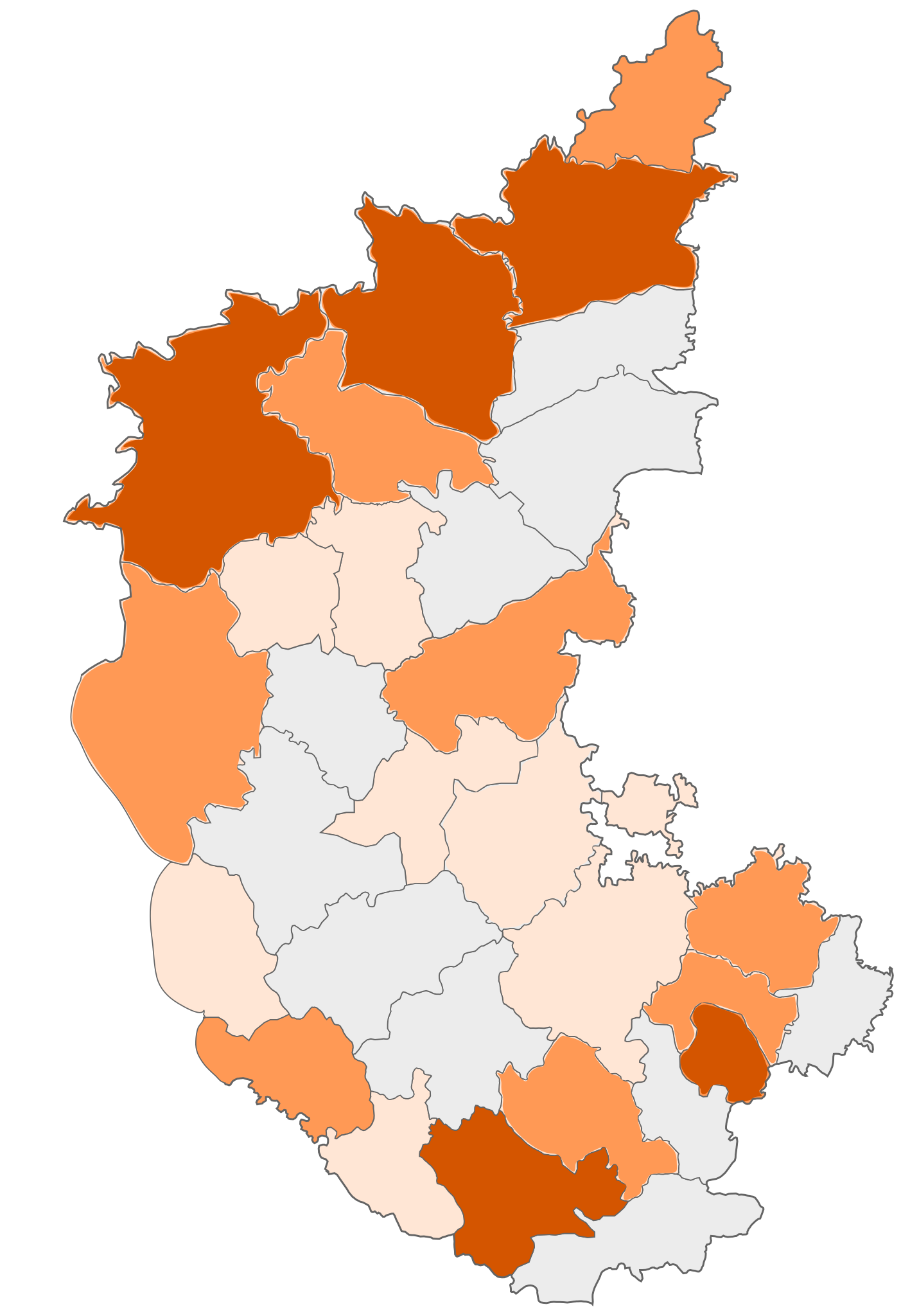
| ವಿವರಣೆ | COVID-19 affected districts in Karnataka state of India as of 7 April 2020. |
| ದಿನೊ | (UTC) |
| ಮೂಲೊ |
This file was derived from: |
| ಲೇಕಕೆರ್ | Firos ak |


| This is a retouched picture, which means that it has been digitally altered from its original version. Modifications: marking COVID 19 district map. The original can be viewed here: India Karnataka COVID-19 map.png:
|
ಪರವಾನಿಗೆ
ಈ ಫೈಲ್ ಕ್ರಿಯೇಟಿವ್ ಕಾಮನ್ಸ್ಡ್ Attribution-Share Alike 3.0 Unported ಲೈಸೆನ್ಸ್ದ ಅಡಿಟ್ ಬರ್ಪುಂಡು.
- ಇರೆಗ್ ಸೊಸಂತ್ರೊ ಉಂಡು:
- ಪಟ್ಯರಗ್ – ಬೇಲೆನ್ ನಕಲ್, ವಿತರಣೆ ಮಲ್ಪೆರೆ ಬೊಕ್ಕ ಸಾಗಾಯೆರೆ
- ಮಿಸ್ರೊ ಮಲ್ಪೆರೆ – ಈ ಬೇಲೆನ್ ಗಲಸೊನಿಯೆರೆ
- ಈ ತಿರ್ತ್ದ ಸರತ್ತುಲೆಡ್:
- ಕೃಪೆ – ಲೇಕಕೆರ್ ಅತ್ತಂಡ ಲೈಸನ್ಸರ್ ವ್ಯಕ್ತೊ ಮಲ್ತಿನ ರೀತಿಡ್ ಲೇಕನೊದ ಶ್ರೇಯೊನು (ಕ್ರೆಡಿಟ್) ಅರೆಗ್ ಕೊರೊಡು .(ಆಂಡ ಇರೆನ್ ಅತ್ತಂಡ ಈರ್ ಲೇಕನೊನು ಗಲಸಿನೇನ್ ಆರ್ ಸಮರ್ಥನೆ ಮಲ್ತಿಲೆಕೊ ತೊಜಪಾವುನ ರೀತಿಡ್ ಅತ್ತ್).
- ಇತ್ತಿನ ಲೆಕೊನೆ ಪಟ್ಟ್ಲೆ – ಈರ್ ಈ ಕೃತಿನ್ ಬದಲಾವಣೆ ಅತ್ತಂಡ ರೂಪಾಂತರ ಮಲ್ತ್ಂಡ, ಅತ್ತಂಡ ಈ ಕೃತಿತ ಮಿತ್ತ್ ಬೇತೆ ದಾಲ ಬೇಲೆ ಮಲ್ತ್ಂಡ, ಐತ ಫಲಿತಾಂಸೊ ಕೃತಿನ್ ಈ ಲೈಸೆನ್ಸ್ ಅತ್ತಂಡ ಇಂಚಿಂತನೆ ಲೈಸೆನ್ಸ್ದ ತಿರ್ತ್ ಮಾತ್ರ ವಿತರಣೆ ಮಲ್ಪೊಲಿ.
Original upload log
This image is a derivative work of the following images:
- File:India Karnataka location map.svg licensed with Cc-by-sa-3.0
- 2010-11-15T15:50:48Z Nayvik 1630x2356 (211689 Bytes) Changed background color
- 2010-11-15T15:34:13Z Nayvik 1630x2356 (211293 Bytes) {{Information |Description=Location map of [[:en:Karnataka|Karnataka]] Geographic limits of the map: * 18.5°N * 11.0°N * 73.6°E * 78.7°E |Source=*[[:File:Karnataka_locator_map.svg|]], [http://www.censusindia.gov.in/2011-I
- File:Karnataka locator map.svg licensed with Cc-by-sa-3.0
- 2010-11-20T10:48:54Z Nayvik 1630x2356 (240130 Bytes) Created 3 new districts [[:en:Chikballapur district|Chikballapur district]], [[:en:Ramanagara district|Ramanagara district]] and [[:en:Yadgir district|Yadgir district]]
- 2007-05-08T10:07:08Z Planemad 1630x2356 (231256 Bytes) chg color of chamarajanagar
- 2007-05-06T13:55:02Z Planemad 1630x2356 (231773 Bytes) {{WikiProject_India_Maps |Title=Karnataka locator Map |Description=Map of [[w:Karnataka]] with road and rail lines |Source= [http://aquarium.lipetsk.ru/discovery/India2004/karnataka-map.jpg Karnataka Map], [http://www.indianr
- File:India Karnataka COVID-19 map.png licensed with Cc-by-sa-3.0
- 2020-03-21T10:18:11Z Firos ak 1630x2356 (400039 Bytes) Removed Bangalore rural and added Chikballapur Dist.
- 2020-03-21T09:56:47Z Firos ak 1630x2356 (399619 Bytes) Added Bangalore rural
- 2020-03-21T08:17:25Z Firos ak 1630x2356 (397871 Bytes) Added Kodagu district
- 2020-03-17T09:22:44Z Shanze1 2608x3768 (686680 Bytes) fix
- 2020-03-17T09:17:26Z Shanze1 2379x3711 (702913 Bytes) transparency
- 2020-03-17T09:13:51Z Shanze1 1631x2357 (387099 Bytes) == {{int:filedesc}} == {{Information |Description=COVID-19 affected districts in Karnataka state of India as of 17 March 2020. |Source={{Derived from|India Karnataka location map.svg|display=50}} |Date=2020-03-17 09:10 (UTC)
Uploaded with derivativeFX
ಫೈಲ್ದ ಇತಿಹಾಸೊ
ದಿನೊ/ಪೊರ್ತುದ ಮಿತ್ತ್ ಒತ್ತ್ಂಡ ಫೈಲ್ ಆ ಪೊರ್ತುಡು ಎಂಚ ತೋಜೊಂದಿತ್ತ್ಂಡ್ ಪಂದ್ ತೂವೊಲಿ.
| ದಿನೊ/ಪೊರ್ತು | ಎಲ್ಯಚಿತ್ರೊ | ಆಯಾಮೊಲು | ಬಳಕೆದಾರೆರ್ | ಅಬಿಪ್ರಾಯೊ | |
|---|---|---|---|---|---|
| ಇತ್ತೆದ | ೧೯:೫೭, ೨೩ ಎಪ್ರಿಲ್ ೨೦೨೦ | | ೧,೬೩೦ × ೨,೩೫೬ (೨೬೦ KB) | Prasannatb | Kalaburagi - 30+ Vijayapura - 30+ |
| ೧೫:೧೮, ೧೭ ಎಪ್ರಿಲ್ ೨೦೨೦ |  | ೧,೬೩೦ × ೨,೩೫೬ (೨೫೫ KB) | Prasannatb | Mandya - 10+, Ballari - 10+ | |
| ೧೯:೨೩, ೧೬ ಎಪ್ರಿಲ್ ೨೦೨೦ |  | ೧,೬೩೦ × ೨,೩೫೬ (೨೪೯ KB) | Prasannatb | Belagavi -30+ and Vijayapura - 10+ | |
| ೨೨:೪೧, ೧೪ ಎಪ್ರಿಲ್ ೨೦೨೦ |  | ೧,೬೩೦ × ೨,೩೫೬ (೨೩೮ KB) | Prasannatb | Chitradurga - 1+ | |
| ೨೨:೩೩, ೧೪ ಎಪ್ರಿಲ್ ೨೦೨೦ |  | ೧,೬೩೦ × ೨,೩೫೬ (೨೩೫ KB) | Prasannatb | Chikkaballapura, Bengaluru Rural, Uttara Kannada - 10+ | |
| ೧೫:೦೬, ೧೪ ಎಪ್ರಿಲ್ ೨೦೨೦ |  | ೧,೬೩೦ × ೨,೩೫೬ (೨೨೮ KB) | Prasannatb | Bagalkote - 10+ | |
| ೧೪:೦೧, ೧೨ ಎಪ್ರಿಲ್ ೨೦೨೦ |  | ೧,೬೩೦ × ೨,೩೫೬ (೨೨೫ KB) | Prasannatb | Vijayapura - +1 | |
| ೧೪:೧೭, ೧೦ ಎಪ್ರಿಲ್ ೨೦೨೦ |  | ೧,೬೩೦ × ೨,೩೫೬ (೨೨೨ KB) | Prasannatb | Kalaburagi - 10+ | |
| ೧೯:೫೪, ೯ ಎಪ್ರಿಲ್ ೨೦೨೦ |  | ೧,೬೩೦ × ೨,೩೫೬ (೨೧೮ KB) | Prasannatb | Belagavi - 10+ | |
| ೨೦:೫೮, ೭ ಎಪ್ರಿಲ್ ೨೦೨೦ |  | ೧,೬೩೦ × ೨,೩೫೬ (೨೧೨ KB) | Firos ak | 7 apr |
ಫೈಲ್ದ ಉಪಯೋಗ
ಈ ತಿರ್ತ್ದ ಪುಟೊ ಈ ಫೈಲ್ಗ್ ಸಂಪರ್ಕೊ ಕೊರ್ಪುಂಡು.
ಜಾಗತಿಕೊ ಫೈಲ್ ಉಪಯೋಗೊ
ಈ ಫೈಲ್ನ್ ತಿರ್ತ್ ಉಪ್ಪುನ ಬೇತೆ ವಿಕಿಲು ಗಲಸುವ:
- en.wikipedia.org ಮಿತ್ತ್ ಉಪಯೋಗೊ
- kn.wikipedia.org ಮಿತ್ತ್ ಉಪಯೋಗೊ
- te.wikipedia.org ಮಿತ್ತ್ ಉಪಯೋಗೊ
- tr.wikipedia.org ಮಿತ್ತ್ ಉಪಯೋಗೊ
- ur.wikipedia.org ಮಿತ್ತ್ ಉಪಯೋಗೊ
- www.wikidata.org ಮಿತ್ತ್ ಉಪಯೋಗೊ