
ಫೈಲ್:India Karnataka location map.svg

Size of this PNG preview of this SVG file: ೪೨೩ × ೬೦೦ ಚಿತ್ರೊ ಬಿಂದುಲು. ಬೇತೆಪಟೊತ್ತ ಗಾತ್ರೊ: ೧೬೯ × ೨೪೦ ಚಿತ್ರೊ ಬಿಂದುಲು | ೩೩೮ × ೪೮೦ ಚಿತ್ರೊ ಬಿಂದುಲು | ೫೪೨ × ೭೬೮ ಚಿತ್ರೊ ಬಿಂದುಲು | ೭೨೨ × ೧,೦೨೪ ಚಿತ್ರೊ ಬಿಂದುಲು | ೧,೪೪೫ × ೨,೦೪೮ ಚಿತ್ರೊ ಬಿಂದುಲು | ೮೯೮ × ೧,೨೭೩ ಚಿತ್ರೊ ಬಿಂದುಲು.
ಮೂಲೊ ಫೈಲ್ (ಎಸ್.ವಿ.ಜಿ ಫೈಲ್, ಸುಮಾರಾದ್ ೮೯೮ × ೧,೨೭೩ ಚಿತ್ರೊಬಿಂದು, ಫೈಲ್ದ ಗಾತ್ರ: ೭೫೯ KB)
| ವಿವರಣೆ |
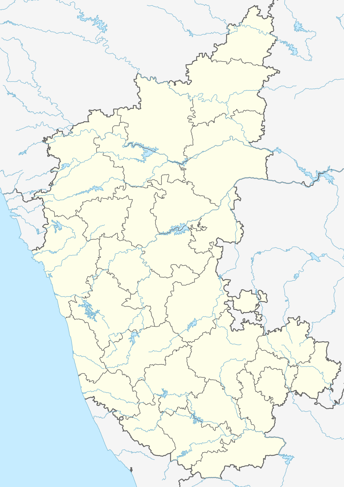
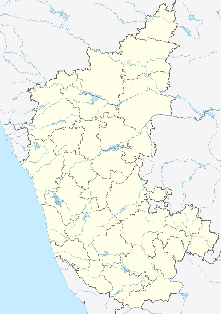
Location map of Karnataka Geographic limits of the map:
|
| ದಿನೊ | (UTC) |
| ಮೂಲೊ | |
| ಲೇಕಕೆರ್ |
|
| ಇತರೆ ಆವೃತ್ತಿಗಳು |
Derivative works of this file: |
| This is a retouched picture, which means that it has been digitally altered from its original version. Modifications: Created 3 new districts Chikkaballapur, Ramanagara and Yadgir. Changed conventions per WP:WPMAP. The original can be viewed here: Karnataka locator map.svg:
|
ಈ ಫೈಲ್ ಕ್ರಿಯೇಟಿವ್ ಕಾಮನ್ಸ್ಡ್ Attribution-Share Alike 3.0 Unported ಲೈಸೆನ್ಸ್ದ ಅಡಿಟ್ ಬರ್ಪುಂಡು.
- ಇರೆಗ್ ಸೊಸಂತ್ರೊ ಉಂಡು:
- ಪಟ್ಯರಗ್ – ಬೇಲೆನ್ ನಕಲ್, ವಿತರಣೆ ಮಲ್ಪೆರೆ ಬೊಕ್ಕ ಸಾಗಾಯೆರೆ
- ಮಿಸ್ರೊ ಮಲ್ಪೆರೆ – ಈ ಬೇಲೆನ್ ಗಲಸೊನಿಯೆರೆ
- ಈ ತಿರ್ತ್ದ ಸರತ್ತುಲೆಡ್:
- ಕೃಪೆ – ಲೇಕಕೆರ್ ಅತ್ತಂಡ ಲೈಸನ್ಸರ್ ವ್ಯಕ್ತೊ ಮಲ್ತಿನ ರೀತಿಡ್ ಲೇಕನೊದ ಶ್ರೇಯೊನು (ಕ್ರೆಡಿಟ್) ಅರೆಗ್ ಕೊರೊಡು .(ಆಂಡ ಇರೆನ್ ಅತ್ತಂಡ ಈರ್ ಲೇಕನೊನು ಗಲಸಿನೇನ್ ಆರ್ ಸಮರ್ಥನೆ ಮಲ್ತಿಲೆಕೊ ತೊಜಪಾವುನ ರೀತಿಡ್ ಅತ್ತ್).
- ಇತ್ತಿನ ಲೆಕೊನೆ ಪಟ್ಟ್ಲೆ – ಈರ್ ಈ ಕೃತಿನ್ ಬದಲಾವಣೆ ಅತ್ತಂಡ ರೂಪಾಂತರ ಮಲ್ತ್ಂಡ, ಅತ್ತಂಡ ಈ ಕೃತಿತ ಮಿತ್ತ್ ಬೇತೆ ದಾಲ ಬೇಲೆ ಮಲ್ತ್ಂಡ, ಐತ ಫಲಿತಾಂಸೊ ಕೃತಿನ್ ಈ ಲೈಸೆನ್ಸ್ ಅತ್ತಂಡ ಇಂಚಿಂತನೆ ಲೈಸೆನ್ಸ್ದ ತಿರ್ತ್ ಮಾತ್ರ ವಿತರಣೆ ಮಲ್ಪೊಲಿ.
Original upload log
This image is a derivative work of the following images:
- File:Karnataka_locator_map.svg licensed with Cc-by-sa-3.0
- 2007-05-06T13:55:02Z Planemad 1630x2356 (231773 Bytes) {{WikiProject_India_Maps |Title=Karnataka locator Map |Description=Map of [[w:Karnataka]] with road and rail lines |Source= [http://aquarium.lipetsk.ru/discovery/India2004/karnataka-map.jpg Karnataka Map], [http://www.indianr
Uploaded with derivativeFX
ಫೈಲ್ದ ಇತಿಹಾಸೊ
ದಿನೊ/ಪೊರ್ತುದ ಮಿತ್ತ್ ಒತ್ತ್ಂಡ ಫೈಲ್ ಆ ಪೊರ್ತುಡು ಎಂಚ ತೋಜೊಂದಿತ್ತ್ಂಡ್ ಪಂದ್ ತೂವೊಲಿ.
| ದಿನೊ/ಪೊರ್ತು | ಎಲ್ಯಚಿತ್ರೊ | ಆಯಾಮೊಲು | ಬಳಕೆದಾರೆರ್ | ಅಬಿಪ್ರಾಯೊ | |
|---|---|---|---|---|---|
| ಇತ್ತೆದ | ೦೮:೪೦, ೧೬ ಜೂನ್ ೨೦೨೩ | | ೮೯೮ × ೧,೨೭೩ (೭೫೯ KB) | C1MM | c Vijayanagara district |
| ೧೦:೧೧, ೧೩ ಆಗೋಸ್ಟು ೨೦೨೧ |  | ೮೫೧ × ೧,೨೧೧ (೫೮೨ KB) | C1MM | Added more rivers | |
| ೦೯:೦೩, ೧೬ ಜುಲಾಯಿ ೨೦೨೧ |  | ೮೫೧ × ೧,೨೧೧ (೫೬೧ KB) | C1MM | Added more accurate district boundaries | |
| ೦೫:೧೧, ೧೫ ದಸಂಬರ್ ೨೦೨೦ |  | ೧,೬೩೪ × ೨,೩೬೭ (೩೪೧ KB) | C1MM | Fixed boundaries of Vijayanagara district | |
| ೦೩:೪೦, ೧೫ ದಸಂಬರ್ ೨೦೨೦ |  | ೧,೬೩೪ × ೨,೩೬೭ (೩೪೫ KB) | C1MM | Added boundaries of AP/Telangana and rivers | |
| ೦೦:೫೬, ೧೪ ದಸಂಬರ್ ೨೦೨೦ |  | ೧,೬೩೪ × ೨,೩೬೭ (೩೪೨ KB) | C1MM | Fixed district boundaries of Ballari and added Vijayanagara district | |
| ೦೯:೨೩, ೨೧ ಎಪ್ರಿಲ್ ೨೦೨೦ |  | ೧,೬೩೪ × ೨,೩೬೭ (೨೮೯ KB) | C1MM | Added rivers | |
| ೨೧:೨೦, ೧೫ ನವಂಬರ್ ೨೦೧೦ |  | ೧,೬೩೦ × ೨,೩೫೬ (೨೦೭ KB) | Nayvik | Changed background color | |
| ೨೧:೦೪, ೧೫ ನವಂಬರ್ ೨೦೧೦ |  | ೧,೬೩೦ × ೨,೩೫೬ (೨೦೬ KB) | Nayvik | {{Information |Description=Location map of Karnataka Geographic limits of the map: * 18.5°N * 11.0°N * 73.6°E * 78.7°E |Source=*File:Karnataka_locator_map.svg, [http://www.censusindia.gov.in/2011-Images/ADMINI2011.jpg Census In |
ಫೈಲ್ದ ಉಪಯೋಗ
ಈ ತಿರ್ತ್ದ 20 ಪುಟೊಕುಲು ಈ ಫೈಲ್ಗ್ ಸಂಪರ್ಕೊ ಕೊರ್ಪುಂಡು.
ಜಾಗತಿಕೊ ಫೈಲ್ ಉಪಯೋಗೊ
ಈ ಫೈಲ್ನ್ ತಿರ್ತ್ ಉಪ್ಪುನ ಬೇತೆ ವಿಕಿಲು ಗಲಸುವ:
- ar.wikipedia.org ಮಿತ್ತ್ ಉಪಯೋಗೊ
- as.wikipedia.org ಮಿತ್ತ್ ಉಪಯೋಗೊ
- azb.wikipedia.org ಮಿತ್ತ್ ಉಪಯೋಗೊ
- تومکور
- بنقلور
- عباسی، کارناتاکا
- اودقولام
- پیکلیهال
- اوداجی (هیندوستان)
- اوچیلا, اودوپی دیستریکت
- اوچاواد
- او خاناپور
- ویراهانوماکاناپالیا
- فاجیر (هیندوستان)
- پتالور (هیندوستان)
- پت آماپور
- ویراکامبا
- ویراپور
- وانور (هیندوستان)
- ساتیجری
- ساتانور, ماقادی
- ساتانور, بانقالور
- ساسالاتی
- سارقور
- ساراواد
- ساراپادی
- ساپتاساقار
- سانتور
- سانتکاسالاجر
- مایاکوندا
- ساناتی
- ماویناکر
- ماوالی
- ماتیواد
- کالادکا
- سانیکاتا
- کالکونت
- کالکری
- ماتماری
- سانقاناهالا
- کالجی (هیندوستان)
- سانقامشوارا, کالاقاتاجی
- ماتاداکوروباراهاتی
- ماستیهولی
- کالاسا, کوندقول
- ماسارکال
- ماسابینال
ಈ ಫೈಲ್ದ ನನಾತ್ ಜಾಗತಿಕ ಉಪಯೋಗೊನು ತೂಲೆ.