
ಫೈಲ್:Karnataka UK locator map.svg

Size of this PNG preview of this SVG file: ೪೨೩ × ೬೦೦ ಚಿತ್ರೊ ಬಿಂದುಲು. ಬೇತೆಪಟೊತ್ತ ಗಾತ್ರೊ: ೧೬೯ × ೨೪೦ ಚಿತ್ರೊ ಬಿಂದುಲು | ೩೩೮ × ೪೮೦ ಚಿತ್ರೊ ಬಿಂದುಲು | ೫೪೨ × ೭೬೮ ಚಿತ್ರೊ ಬಿಂದುಲು | ೭೨೨ × ೧,೦೨೪ ಚಿತ್ರೊ ಬಿಂದುಲು | ೧,೪೪೫ × ೨,೦೪೮ ಚಿತ್ರೊ ಬಿಂದುಲು | ೮೯೮ × ೧,೨೭೩ ಚಿತ್ರೊ ಬಿಂದುಲು.
ಮೂಲೊ ಫೈಲ್ (ಎಸ್.ವಿ.ಜಿ ಫೈಲ್, ಸುಮಾರಾದ್ ೮೯೮ × ೧,೨೭೩ ಚಿತ್ರೊಬಿಂದು, ಫೈಲ್ದ ಗಾತ್ರ: ೯೩೭ KB)
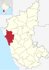
| ವಿವರಣೆ | Location map of Uttara Kannada district in Karnataka. |
| ದಿನೊ | (UTC) |
| ಮೂಲೊ | |
| ಲೇಕಕೆರ್ |
|
| This is a retouched picture, which means that it has been digitally altered from its original version. Modifications: Highlighted Uttara Kannada district. The original can be viewed here: India Karnataka location map.svg:
|
ಈ ಫೈಲ್ ಕ್ರಿಯೇಟಿವ್ ಕಾಮನ್ಸ್ಡ್ Attribution-Share Alike 3.0 Unported ಲೈಸೆನ್ಸ್ದ ಅಡಿಟ್ ಬರ್ಪುಂಡು.
- ಇರೆಗ್ ಸೊಸಂತ್ರೊ ಉಂಡು:
- ಪಟ್ಯರಗ್ – ಬೇಲೆನ್ ನಕಲ್, ವಿತರಣೆ ಮಲ್ಪೆರೆ ಬೊಕ್ಕ ಸಾಗಾಯೆರೆ
- ಮಿಸ್ರೊ ಮಲ್ಪೆರೆ – ಈ ಬೇಲೆನ್ ಗಲಸೊನಿಯೆರೆ
- ಈ ತಿರ್ತ್ದ ಸರತ್ತುಲೆಡ್:
- ಕೃಪೆ – ಲೇಕಕೆರ್ ಅತ್ತಂಡ ಲೈಸನ್ಸರ್ ವ್ಯಕ್ತೊ ಮಲ್ತಿನ ರೀತಿಡ್ ಲೇಕನೊದ ಶ್ರೇಯೊನು (ಕ್ರೆಡಿಟ್) ಅರೆಗ್ ಕೊರೊಡು .(ಆಂಡ ಇರೆನ್ ಅತ್ತಂಡ ಈರ್ ಲೇಕನೊನು ಗಲಸಿನೇನ್ ಆರ್ ಸಮರ್ಥನೆ ಮಲ್ತಿಲೆಕೊ ತೊಜಪಾವುನ ರೀತಿಡ್ ಅತ್ತ್).
- ಇತ್ತಿನ ಲೆಕೊನೆ ಪಟ್ಟ್ಲೆ – ಈರ್ ಈ ಕೃತಿನ್ ಬದಲಾವಣೆ ಅತ್ತಂಡ ರೂಪಾಂತರ ಮಲ್ತ್ಂಡ, ಅತ್ತಂಡ ಈ ಕೃತಿತ ಮಿತ್ತ್ ಬೇತೆ ದಾಲ ಬೇಲೆ ಮಲ್ತ್ಂಡ, ಐತ ಫಲಿತಾಂಸೊ ಕೃತಿನ್ ಈ ಲೈಸೆನ್ಸ್ ಅತ್ತಂಡ ಇಂಚಿಂತನೆ ಲೈಸೆನ್ಸ್ದ ತಿರ್ತ್ ಮಾತ್ರ ವಿತರಣೆ ಮಲ್ಪೊಲಿ.
Original upload log
This image is a derivative work of the following images:
- File:India_Karnataka_location_map.svg licensed with Cc-by-sa-3.0
- 2010-11-15T15:50:48Z Nayvik 1630x2356 (211689 Bytes) Changed background color
- 2010-11-15T15:34:13Z Nayvik 1630x2356 (211293 Bytes) {{Information |Description=Location map of [[:en:Karnataka|Karnataka]] Geographic limits of the map: * 18.5°N * 11.0°N * 73.6°E * 78.7°E |Source=*[[:File:Karnataka_locator_map.svg|]], [http://www.censusindia.gov.in/2011-I
Uploaded with derivativeFX
ಫೈಲ್ದ ಇತಿಹಾಸೊ
ದಿನೊ/ಪೊರ್ತುದ ಮಿತ್ತ್ ಒತ್ತ್ಂಡ ಫೈಲ್ ಆ ಪೊರ್ತುಡು ಎಂಚ ತೋಜೊಂದಿತ್ತ್ಂಡ್ ಪಂದ್ ತೂವೊಲಿ.
| ದಿನೊ/ಪೊರ್ತು | ಎಲ್ಯಚಿತ್ರೊ | ಆಯಾಮೊಲು | ಬಳಕೆದಾರೆರ್ | ಅಬಿಪ್ರಾಯೊ | |
|---|---|---|---|---|---|
| ಇತ್ತೆದ | ೦೯:೦೭, ೧೬ ಜೂನ್ ೨೦೨೩ | | ೮೯೮ × ೧,೨೭೩ (೯೩೭ KB) | C1MM | updated bounds |
| ೦೯:೧೯, ೧೬ ಜುಲಾಯಿ ೨೦೨೧ |  | ೮೫೧ × ೧,೨೧೧ (೧.೦೫ MB) | C1MM | c bounds | |
| ೨೩:೧೪, ೨೦ ನವಂಬರ್ ೨೦೧೦ |  | ೧,೬೩೦ × ೨,೩೫೬ (೨೦೭ KB) | Nayvik | {{Information |Description=Location map of Uttara Kannada district in Karnataka. |Source=*File:India_Karnataka_location_map.svg |Date=2010-11-20 17:43 (UTC) |Author=*File:India_Karnataka_location_map.svg: *[[:Fi |
ಫೈಲ್ದ ಉಪಯೋಗ
ಈ ತಿರ್ತ್ದ ಪುಟೊ ಈ ಫೈಲ್ಗ್ ಸಂಪರ್ಕೊ ಕೊರ್ಪುಂಡು.
ಜಾಗತಿಕೊ ಫೈಲ್ ಉಪಯೋಗೊ
ಈ ಫೈಲ್ನ್ ತಿರ್ತ್ ಉಪ್ಪುನ ಬೇತೆ ವಿಕಿಲು ಗಲಸುವ:
- ar.wikipedia.org ಮಿತ್ತ್ ಉಪಯೋಗೊ
- arz.wikipedia.org ಮಿತ್ತ್ ಉಪಯೋಗೊ
- azb.wikipedia.org ಮಿತ್ತ್ ಉಪಯೋಗೊ
- bh.wikipedia.org ಮಿತ್ತ್ ಉಪಯೋಗೊ
- bn.wikipedia.org ಮಿತ್ತ್ ಉಪಯೋಗೊ
- ca.wikipedia.org ಮಿತ್ತ್ ಉಪಯೋಗೊ
- de.wikipedia.org ಮಿತ್ತ್ ಉಪಯೋಗೊ
- en.wikipedia.org ಮಿತ್ತ್ ಉಪಯೋಗೊ
- es.wikipedia.org ಮಿತ್ತ್ ಉಪಯೋಗೊ
- eu.wikipedia.org ಮಿತ್ತ್ ಉಪಯೋಗೊ
- fa.wikipedia.org ಮಿತ್ತ್ ಉಪಯೋಗೊ
- fr.wikipedia.org ಮಿತ್ತ್ ಉಪಯೋಗೊ
- hi.wikipedia.org ಮಿತ್ತ್ ಉಪಯೋಗೊ
- id.wikipedia.org ಮಿತ್ತ್ ಉಪಯೋಗೊ
- it.wikipedia.org ಮಿತ್ತ್ ಉಪಯೋಗೊ
- kn.wikipedia.org ಮಿತ್ತ್ ಉಪಯೋಗೊ
- ml.wikipedia.org ಮಿತ್ತ್ ಉಪಯೋಗೊ
- mr.wikipedia.org ಮಿತ್ತ್ ಉಪಯೋಗೊ
- nl.wikipedia.org ಮಿತ್ತ್ ಉಪಯೋಗೊ
ಈ ಫೈಲ್ದ ನನಾತ್ ಜಾಗತಿಕ ಉಪಯೋಗೊನು ತೂಲೆ.