
ಫೈಲ್:Proposed states and territories of India.png
ಈ ಮುನ್ನೋಟದ ಗಾತ್ರೊ: ೫೬೯ × ೬೦೦ ಚಿತ್ರೊ ಬಿಂದುಲು. ಬೇತೆಪಟೊತ್ತ ಗಾತ್ರೊ: ೨೨೮ × ೨೪೦ ಚಿತ್ರೊ ಬಿಂದುಲು | ೪೫೫ × ೪೮೦ ಚಿತ್ರೊ ಬಿಂದುಲು | ೭೨೮ × ೭೬೮ ಚಿತ್ರೊ ಬಿಂದುಲು | ೯೭೧ × ೧,೦೨೪ ಚಿತ್ರೊ ಬಿಂದುಲು | ೧,೪೫೬ × ೧,೫೩೫ ಚಿತ್ರೊ ಬಿಂದುಲು.
ಮೂಲೊ ಫೈಲ್ (೧,೪೫೬ × ೧,೫೩೫ ಚಿತ್ರಬಿಂದುಲು, ಫೈಲ್ದ ಗಾತ್ರೊ: ೩೩೨ KB, MIME ಪ್ರಕಾರೊ: image/png)

|
File:Proposed states and union territories of India.svg is a vector version of this file. It should be used in place of this PNG file when not inferior.
File:Proposed states and territories of India.png → File:Proposed states and union territories of India.svg
For more information, see Help:SVG. |
 |
| ವಿವರಣೆ |
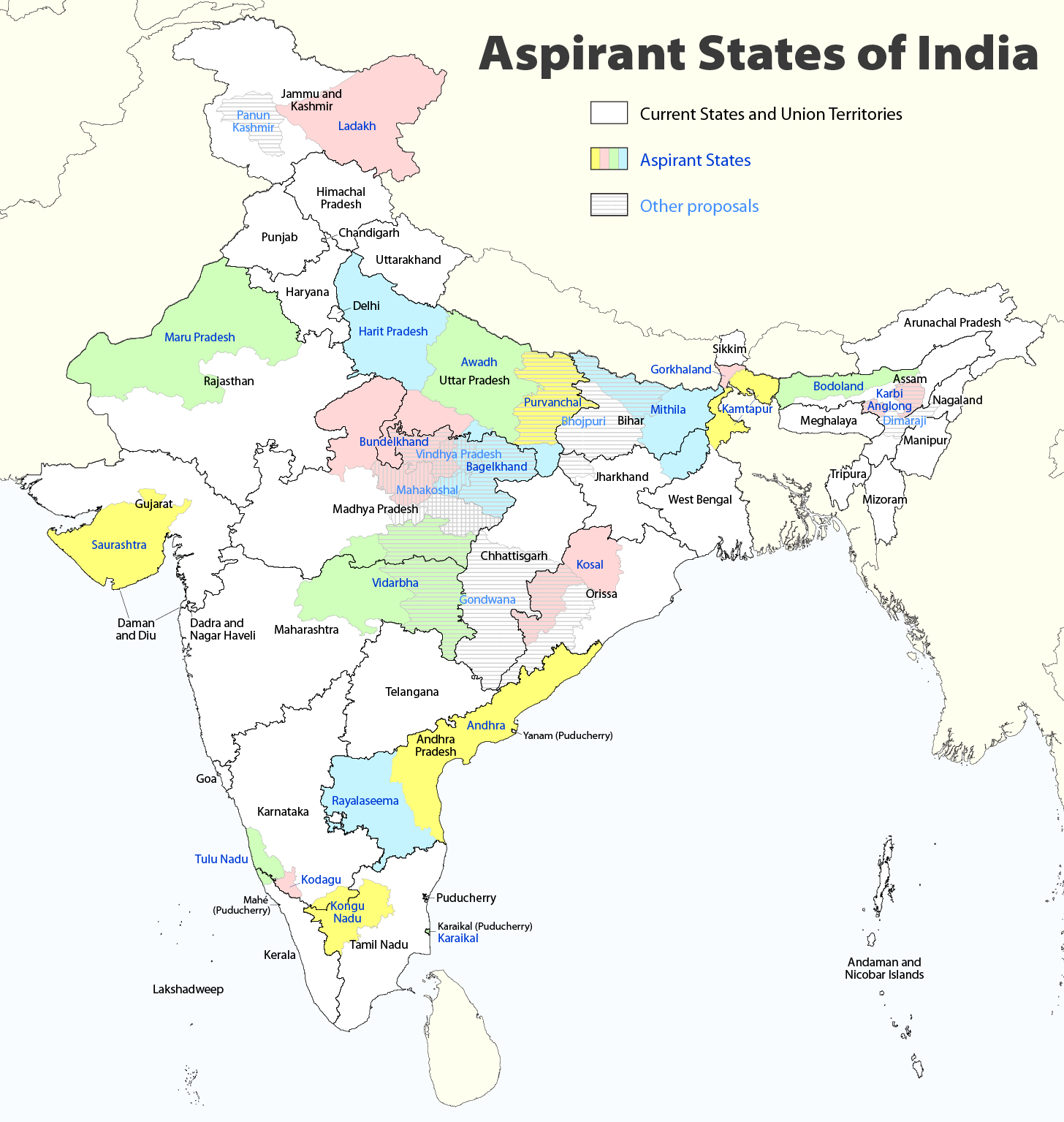
Deutsch: Indiens Anwärterstaaten
English: Aspirant States of India |
| ದಿನೊ | |
| ಮೂಲೊ | ಸೊಂತೊ ರಚನೆ |
| ಲೇಕಕೆರ್ | Maximilian Dörrbecker (Chumwa) |
| ಒಪ್ಪುಗೆ (ಈ ಫೈಲ್ನ್ ಕುಡ ಗಲಸೊಂದುಂಡು) |
I, the copyright holder of this work, hereby publish it under the following license: This file is licensed under the Creative Commons Attribution-Share Alike 2.5 Generic license.
Sie dürfen das Bild zu den folgenden Bedingungen nutzen:
|
| ಇತರೆ ಆವೃತ್ತಿಗಳು |
|

ಫೈಲ್ದ ಇತಿಹಾಸೊ
ದಿನೊ/ಪೊರ್ತುದ ಮಿತ್ತ್ ಒತ್ತ್ಂಡ ಫೈಲ್ ಆ ಪೊರ್ತುಡು ಎಂಚ ತೋಜೊಂದಿತ್ತ್ಂಡ್ ಪಂದ್ ತೂವೊಲಿ.
| ದಿನೊ/ಪೊರ್ತು | ಎಲ್ಯಚಿತ್ರೊ | ಆಯಾಮೊಲು | ಬಳಕೆದಾರೆರ್ | ಅಬಿಪ್ರಾಯೊ | |
|---|---|---|---|---|---|
| ಇತ್ತೆದ | ೧೪:೩೬, ೨ ಆಗೋಸ್ಟು ೨೦೨೦ | | ೧,೪೫೬ × ೧,೫೩೫ (೩೩೨ KB) | Chumwa | Reverted to version as of 21:03, 29 August 2018 (UTC) |
| ೦೧:೩೩, ೩೧ ಜುಲಾಯಿ ೨೦೨೦ |  | ೧,೪೫೬ × ೧,೫೩೫ (೩೧೬ KB) | UT'sIndia | Reverted to version as of 15:15, 17 May 2013 (UTC) | |
| ೦೨:೩೩, ೩೦ ಆಗೋಸ್ಟು ೨೦೧೮ |  | ೧,೪೫೬ × ೧,೫೩೫ (೩೩೨ KB) | Chumwa | extended Tulu Nadu into Kerala | |
| ೦೩:೨೨, ೬ ಜೂನ್ ೨೦೧೪ |  | ೧,೪೫೬ × ೧,೫೩೫ (೩೩೨ KB) | Chumwa | borders of Rayalseema corrected | |
| ೨೩:೫೩, ೩ ಜೂನ್ ೨೦೧೪ |  | ೧,೪೫೬ × ೧,೫೩೫ (೩೩೨ KB) | Chumwa | borders of Mithila corrected | |
| ೨೩:೨೩, ೩ ಜೂನ್ ೨೦೧೪ |  | ೧,೪೫೬ × ೧,೫೩೫ (೩೩೧ KB) | Chumwa | Telangana now is an official state | |
| ೨೦:೪೬, ೧೭ ಮೇ ೨೦೧೩ |  | ೧,೪೫೬ × ೧,೫೩೫ (೩೧೬ KB) | Cromium | Removed large title; enlarged map key with slightly different wording | |
| ೨೦:೪೫, ೧೭ ಮೇ ೨೦೧೩ |  | ೧,೪೫೬ × ೧,೫೩೫ (೩೧೬ KB) | Cromium | Removed large title; enlarged map key with slightly different wording | |
| ೦೪:೦೨, ೩ ಜನವರಿ ೨೦೧೨ |  | ೧,೪೫೬ × ೧,೫೩೫ (೩೧೨ KB) | Chumwa | added some other aspirant states | |
| ೦೨:೪೬, ೩ ಜನವರಿ ೨೦೧೨ |  | ೧,೪೫೬ × ೧,೫೩೫ (೨೯೨ KB) | Chumwa | added a map key |
ಫೈಲ್ದ ಉಪಯೋಗ
ಈ ತಿರ್ತ್ದ ಪುಟೊ ಈ ಫೈಲ್ಗ್ ಸಂಪರ್ಕೊ ಕೊರ್ಪುಂಡು.
ಜಾಗತಿಕೊ ಫೈಲ್ ಉಪಯೋಗೊ
ಈ ಫೈಲ್ನ್ ತಿರ್ತ್ ಉಪ್ಪುನ ಬೇತೆ ವಿಕಿಲು ಗಲಸುವ:
- bn.wikipedia.org ಮಿತ್ತ್ ಉಪಯೋಗೊ
- de.wikipedia.org ಮಿತ್ತ್ ಉಪಯೋಗೊ
- en.wikipedia.org ಮಿತ್ತ್ ಉಪಯೋಗೊ
- Delhi
- Gondwana (India)
- Kodagu district
- Mithila (proposed Indian state)
- Awadh
- Vidarbha
- Bundelkhand
- Bagelkhand
- Tulu Nadu
- Rayalaseema
- Purvanchal
- Bodoland Territorial Region
- Karbi Anglong district
- Mahakoshal
- Kongu Nadu
- Cooch Behar district
- Gird, India
- Mara Autonomous District Council
- Tripura Tribal Areas Autonomous District Council
- Malabar District
- Gorkhaland movement
- Kamtapur
- Proposed states and union territories of India
- Autonomous administrative divisions of India
- Karaikal district
- Panun Kashmir
- Chakma Autonomous District Council
- Lai Autonomous District Council
- Khasi Hills Autonomous District Council
- Jaintia Hills Autonomous District Council
- Garo Hills Autonomous District Council
- Template:Proposed states and union territories of India
- Tulu Nadu state movement
- Kosal state movement
- User:AbhisheksinghWIKI/Law and Order(India)
- Gorkhaland Territorial Administration
- Tipraland
- Kalyana-Karnataka
- Sadar Hills
- West Karbi Anglong district
ಈ ಫೈಲ್ದ ನನಾತ್ ಜಾಗತಿಕ ಉಪಯೋಗೊನು ತೂಲೆ.