
ಫೈಲ್:Badami-chalukya-empire-map.svg

ಮೂಲೊ ಫೈಲ್ (ಎಸ್.ವಿ.ಜಿ ಫೈಲ್, ಸುಮಾರಾದ್ ೧,೫೧೦ × ೧,೭೫೩ ಚಿತ್ರೊಬಿಂದು, ಫೈಲ್ದ ಗಾತ್ರ: ೩೩೯ KB)
ಸಾರಾಂಸೊ
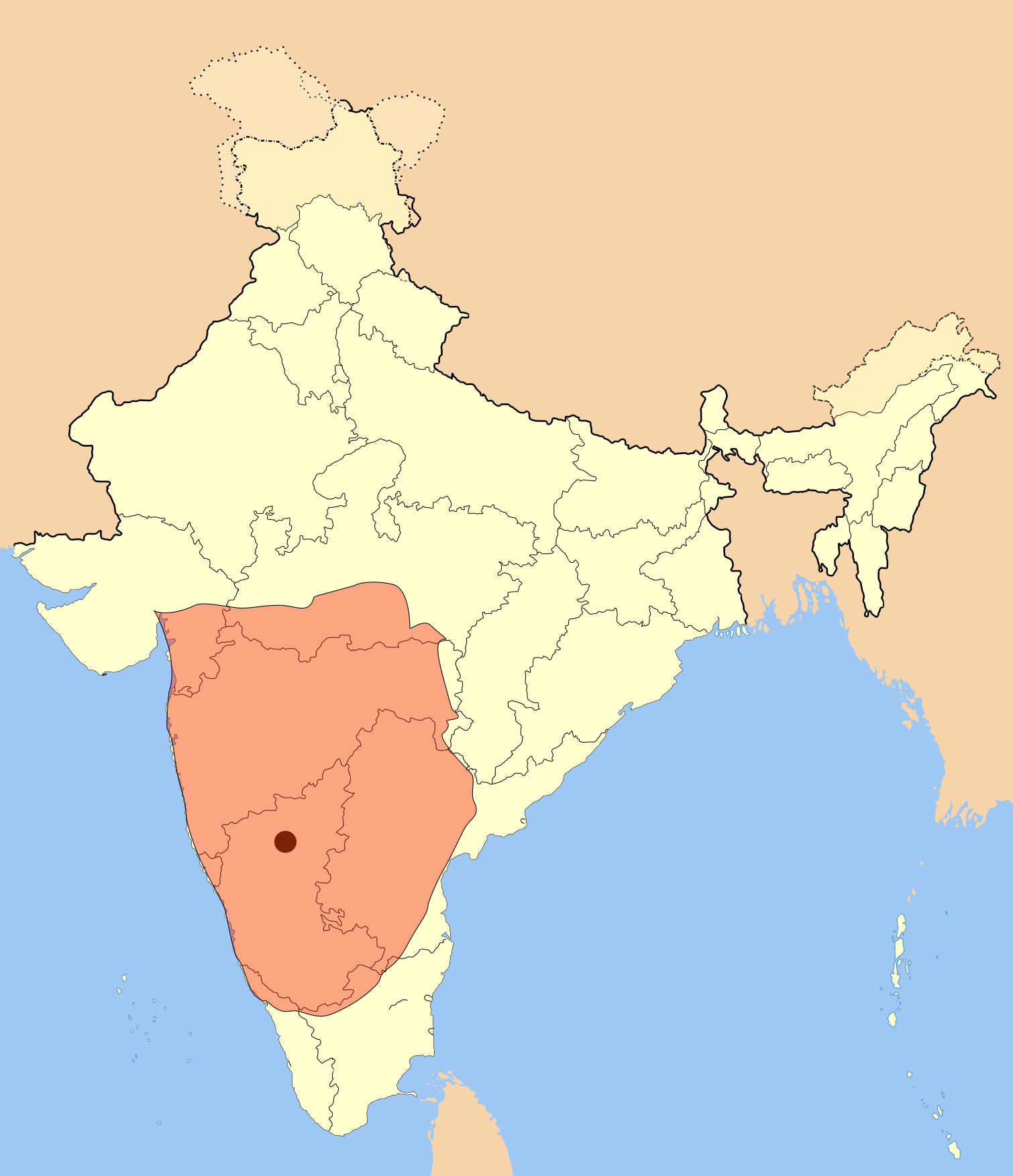
I used Image:India-locator-map-blank.svg as base and edited myself using inkspace and created it by looking at the following source.
Suryanath U. Kamat, A Concise history of Karnataka from pre-historic times to the present, Jupiter books, MCC, Bangalore, 2001 (Reprinted 2002) OCLC: 7796041 p327
A province of this empire comprising of Andhra region became the "Eastern Chalukyas" in the years following the death of Pulakesi II.
Note: Original source has overlay of Kadamba, Rastrakuta and Western Ganga kingdom maps on the same page, I placed only the Badami Chalukya empire map.
| ವಿವರಣೆ | Badami Chalukya Empire Map |
| ದಿನೊ | |
| ಮೂಲೊ | ಸೊಂತೊ ರಚನೆ |
| ಲೇಕಕೆರ್ | Mlpkr |
ಪರವಾನಿಗೆ

|
ಈ ಲೇಕನೊನು ಫ್ರೀ ಸಾಫ್ಟ್ವೇರ್ ಫೌಂಡೇಶನ್ಡ್ದ್ ಪ್ರಕಟನೆ ಆಯಿನ ಜಿಎನ್ಯು ಫ್ರೀ ಡಾಕ್ಯುಮೆಂಟೇಶನ್ ಲೈಸೆನ್ಸ್, ಆವೃತ್ತಿ 1.2 ಅತ್ತ್ಡ ಬೊಕ್ಕ ಪ್ರಕಟನೆ ಆಯಿನ ಒವ್ವೇ ಆವೃತ್ತಿದ ನಿಬಂದನೆದಡಿಟ್; ಬದಲ್ ಮಲ್ಪೆರಾವಂದಿನ ವಿಬಾಗೊಲು ದಾಂತೆ, ಫ್ರಂಟ್-ಕವರ್ ಬರವು ದಾಂತೆ, ಬೊಕ್ಕ ಬ್ಯಾಕ್-ಕವರ್ ಬರವು ದಾಂತೆ; ನಕಲ್ ಮಲ್ಪೆರೆ, ವಿತರಣೆ ಮಲ್ಪೆರೆ ಅತ್ತ್ಡ ಬದಲ್ ಮಲ್ಪೆರೆ ಒಪ್ಪಿಗೆ ಉಂಡು. ಈ ಲೈಸೆನ್ಸ್ದ ಒಂಜಿ ಪ್ರತಿ ಜಿಎನ್ಯು ಫ್ರೀ ಡಾಕ್ಯುಮೆಂಟೇಶನ್ ಲೈಸೆನ್ಸ್ ಪನ್ಪಿ ವಿಬಾಗೊಡು ಉಂಡು. |
| ಈ ಫೈಲ್ ಕ್ರಿಯೇಟಿವ್ ಕಾಮನ್ಸ್ಡ್ Attribution-Share Alike 3.0 Unported ಲೈಸೆನ್ಸ್ದ ಅಡಿಟ್ ಬರ್ಪುಂಡು. | ||
| ||
| This licensing tag was added to this file as part of the GFDL licensing update. |
- ಇರೆಗ್ ಸೊಸಂತ್ರೊ ಉಂಡು:
- ಪಟ್ಯರಗ್ – ಬೇಲೆನ್ ನಕಲ್, ವಿತರಣೆ ಮಲ್ಪೆರೆ ಬೊಕ್ಕ ಸಾಗಾಯೆರೆ
- ಮಿಸ್ರೊ ಮಲ್ಪೆರೆ – ಈ ಬೇಲೆನ್ ಗಲಸೊನಿಯೆರೆ
- ಈ ತಿರ್ತ್ದ ಸರತ್ತುಲೆಡ್:
- ಕೃಪೆ – ಲೇಕಕೆರ್ ಅತ್ತಂಡ ಲೈಸನ್ಸರ್ ವ್ಯಕ್ತೊ ಮಲ್ತಿನ ರೀತಿಡ್ ಲೇಕನೊದ ಶ್ರೇಯೊನು (ಕ್ರೆಡಿಟ್) ಅರೆಗ್ ಕೊರೊಡು .(ಆಂಡ ಇರೆನ್ ಅತ್ತಂಡ ಈರ್ ಲೇಕನೊನು ಗಲಸಿನೇನ್ ಆರ್ ಸಮರ್ಥನೆ ಮಲ್ತಿಲೆಕೊ ತೊಜಪಾವುನ ರೀತಿಡ್ ಅತ್ತ್).
- ಇತ್ತಿನ ಲೆಕೊನೆ ಪಟ್ಟ್ಲೆ – ಈರ್ ಈ ಕೃತಿನ್ ಬದಲಾವಣೆ ಅತ್ತಂಡ ರೂಪಾಂತರ ಮಲ್ತ್ಂಡ, ಅತ್ತಂಡ ಈ ಕೃತಿತ ಮಿತ್ತ್ ಬೇತೆ ದಾಲ ಬೇಲೆ ಮಲ್ತ್ಂಡ, ಐತ ಫಲಿತಾಂಸೊ ಕೃತಿನ್ ಈ ಲೈಸೆನ್ಸ್ ಅತ್ತಂಡ ಇಂಚಿಂತನೆ ಲೈಸೆನ್ಸ್ದ ತಿರ್ತ್ ಮಾತ್ರ ವಿತರಣೆ ಮಲ್ಪೊಲಿ.
ಫೈಲ್ದ ಇತಿಹಾಸೊ
ದಿನೊ/ಪೊರ್ತುದ ಮಿತ್ತ್ ಒತ್ತ್ಂಡ ಫೈಲ್ ಆ ಪೊರ್ತುಡು ಎಂಚ ತೋಜೊಂದಿತ್ತ್ಂಡ್ ಪಂದ್ ತೂವೊಲಿ.
| ದಿನೊ/ಪೊರ್ತು | ಎಲ್ಯಚಿತ್ರೊ | ಆಯಾಮೊಲು | ಬಳಕೆದಾರೆರ್ | ಅಬಿಪ್ರಾಯೊ | |
|---|---|---|---|---|---|
| ಇತ್ತೆದ | ೦೫:೫೮, ೧೯ ಜುಲಾಯಿ ೨೦೧೭ | | ೧,೫೧೦ × ೧,೭೫೩ (೩೩೯ KB) | Renato de Carvalho Ferreira | Ajustes gerais |
| ೦೪:೧೯, ೨೮ ಮೇ ೨೦೦೭ |  | ೧,೬೫೧ × ೧,೭೫೩ (೪೩೨ KB) | Mlpkr | I used Image:India-locator-map-blank.svg as base and edited myself using inkspace and created it by looking at the following source. Suryanath U. Kamat, A Concise history of Karnataka from pre-historic times to the present, Jupiter books, MCC, Bangalore | |
| ೦೪:೩೯, ೨೭ ಮೇ ೨೦೦೭ |  | ೧,೬೫೧ × ೧,೭೫೩ (೪೩೨ KB) | Mlpkr | == Summary == I used Image:India-locator-map-blank.svg as base and edited myself using inkspace and created it by looking at the following source. Suryanath U. Kamat, A Concise history of Karnataka from pre-historic times to the present, Jupiter books, | |
| ೦೩:೫೫, ೨೭ ಮೇ ೨೦೦೭ |  | ೧,೬೫೧ × ೧,೭೫೩ (೪೩೧ KB) | Mlpkr | {{Information |Description= |Source=self-made |Date= |Author= User:Mlpkr }} |
ಫೈಲ್ದ ಉಪಯೋಗ
ಈ ಫೈಲ್ಗ್ ಸಂಪರ್ಕೊ ಉಪ್ಪುನ ವಾ ಪುಟೊಲಾ ಇಜ್ಜಿ.
ಜಾಗತಿಕೊ ಫೈಲ್ ಉಪಯೋಗೊ
ಈ ಫೈಲ್ನ್ ತಿರ್ತ್ ಉಪ್ಪುನ ಬೇತೆ ವಿಕಿಲು ಗಲಸುವ:
- ar.wikipedia.org ಮಿತ್ತ್ ಉಪಯೋಗೊ
- ba.wikipedia.org ಮಿತ್ತ್ ಉಪಯೋಗೊ
- bn.wikipedia.org ಮಿತ್ತ್ ಉಪಯೋಗೊ
- ca.wikipedia.org ಮಿತ್ತ್ ಉಪಯೋಗೊ
- da.wikipedia.org ಮಿತ್ತ್ ಉಪಯೋಗೊ
- en.wikipedia.org ಮಿತ್ತ್ ಉಪಯೋಗೊ
- es.wikipedia.org ಮಿತ್ತ್ ಉಪಯೋಗೊ
- fi.wikipedia.org ಮಿತ್ತ್ ಉಪಯೋಗೊ
- fr.wikipedia.org ಮಿತ್ತ್ ಉಪಯೋಗೊ
- gu.wikipedia.org ಮಿತ್ತ್ ಉಪಯೋಗೊ
- hi.wikipedia.org ಮಿತ್ತ್ ಉಪಯೋಗೊ
- hu.wikipedia.org ಮಿತ್ತ್ ಉಪಯೋಗೊ
- hy.wikipedia.org ಮಿತ್ತ್ ಉಪಯೋಗೊ
- id.wikipedia.org ಮಿತ್ತ್ ಉಪಯೋಗೊ
- it.wikipedia.org ಮಿತ್ತ್ ಉಪಯೋಗೊ
- ja.wikipedia.org ಮಿತ್ತ್ ಉಪಯೋಗೊ
- ka.wikipedia.org ಮಿತ್ತ್ ಉಪಯೋಗೊ
- kn.wikipedia.org ಮಿತ್ತ್ ಉಪಯೋಗೊ
- ko.wikipedia.org ಮಿತ್ತ್ ಉಪಯೋಗೊ
- lt.wikipedia.org ಮಿತ್ತ್ ಉಪಯೋಗೊ
- ml.wikipedia.org ಮಿತ್ತ್ ಉಪಯೋಗೊ
- mr.wikipedia.org ಮಿತ್ತ್ ಉಪಯೋಗೊ
- ms.wikipedia.org ಮಿತ್ತ್ ಉಪಯೋಗೊ
ಈ ಫೈಲ್ದ ನನಾತ್ ಜಾಗತಿಕ ಉಪಯೋಗೊನು ತೂಲೆ.